
News Summary
New Orleans is preparing for significant rainfall and potential flooding as tropical disturbance Invest 93L approaches. A Flood Watch is in effect for Southeast Louisiana, predicting rainfall accumulation between 4-12 inches. With the risk of flash flooding, city officials have closed multiple intersections and urged residents to stay safe. Preparations include sandbag stations, closures of public buildings, and continued monitoring of drainage systems to mitigate the impact of anticipated severe weather.
New Orleans is bracing for heavy rain and potential flooding as a tropical disturbance, referred to as Invest 93L, approaches the region. A Flood Watch has been issued for all of Southeast Louisiana, including New Orleans, which will remain in effect through Friday night. Forecasts predict significant rainfall that could lead to flash flooding in various urban areas.
The disturbance is currently moving over Southeast Louisiana, with expectations of rain accumulation between 4-8 inches across southern parts of the state. Some locations may experience even heavier rainfall, potentially reaching 8-12 inches, with isolated areas at risk for up to 16 inches of rain. Rainfall rates could soar to between 1-3 inches per hour, likely overwhelming local drainage systems, particularly in metro areas like New Orleans.
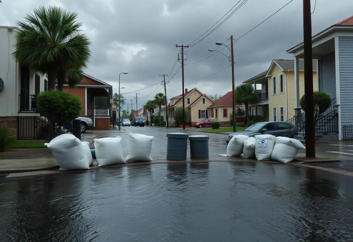
The New Orleans Police Department has taken precautionary measures by closing multiple intersections in areas prone to flooding. A total of 15 intersections have been identified for monitoring due to their susceptibility to rising water levels. City officials have urged residents to respect barricades and safety measures to avoid risking their lives and the safety of first responders.
Significant flash flooding is anticipated in low-lying areas throughout New Orleans, including neighborhoods like Gentilly and Algiers, where drainage pumps are currently facing operational issues. As of July 16, 86 of 93 major drainage pumps in the city were functioning, and all power turbines were available. These pumps usually handle rainfall at a rate of 1 inch per hour initially, followed by 0.5 inch per hour thereafter.
In anticipation of severe weather, residents have been actively preparing by utilizing sandbag stations set up throughout the city. City buildings will be closed to the public on Thursday, July 17, although city services will continue to operate virtually during this period. These measures are part of the city’s response to ensure safety and minimize disruption as the weather situation unfolds.
Several measures have been implemented in the region, including the closure of municipal buildings and the lifting of parking restrictions in specific areas. Residents in Jefferson Parish have reported power outages due to trees falling on power lines, exacerbating the impact of the storm.
AccuWeather experts have indicated that the approaching storm could lead to travel disruptions, loss of revenue for local businesses, and various risks associated with heavy rainfall and flooding. Major cities along Interstate 10—Lafayette to Baton Rouge, Lake Charles, and New Orleans—are expected to be directly impacted, necessitating continued monitoring and preparedness.
As the situation develops, city officials are encouraging the community to stay informed about weather conditions and adhere to safety recommendations. The city anticipates a significant reduction in the impact of the weather system, allowing for city services to resume normal operations by Friday, July 18.
New Orleans continues to prioritize safety and readiness as it enters this period of potential severe weather, working to ensure that residents are equipped with the necessary resources and knowledge to navigate the challenges posed by Invest 93L.
Deeper Dive: News & Info About This Topic
HERE Resources
Tropical Rainstorm to Impact New Orleans with Heavy Flooding
New Orleans Prepares for Tropical Storm and Flooding Risks
New Orleans Prepares for Heavy Rainfall and Flooding Threat
New Orleans Prepares for Heavy Rainfall as Tropical Disturbance Approaches
Louisiana Prepares for Severe Weather as Storm Approaches
New Orleans Prepares for Heavy Rainfall from Tropical System
Flood Watch Issued for Southeast Louisiana
New Orleans Coroner’s Office Halts Autopsies Due to HVAC Failure
Heat Advisory Issued for Southeast Louisiana
Severe Storm Causes Widespread Power Outages in New Orleans
Additional Resources
- AccuWeather: Gulf Tropical Rainstorm Threatens Louisiana
- WDSU: New Orleans Preparing for Heavy Rain and Flooding
- NOLA: New Orleans Weather and Gulf Disturbance
- Axios: Tropical Threat Puts New Orleans on High Alert
- USA Today: New Orleans Weather Impact from Storm
- Wikipedia: New Orleans
- Google Search: New Orleans Weather
- Google Scholar: New Orleans Flooding
- Encyclopedia Britannica: New Orleans
- Google News: New Orleans Weather Flooding

Author: STAFF HERE NEWORLEANS WRITER
The NEW ORLEANS STAFF WRITER represents the experienced team at HERENewOrleans.com, your go-to source for actionable local news and information in New Orleans, Orleans Parish, and beyond. Specializing in "news you can use," we cover essential topics like product reviews for personal and business needs, local business directories, politics, real estate trends, neighborhood insights, and state news affecting the area—with deep expertise drawn from years of dedicated reporting and strong community input, including local press releases and business updates. We deliver top reporting on high-value events such as French Quarter Festival, New Orleans Jazz & Heritage Festival, and Essence Music Festival. Our coverage extends to key organizations like the New Orleans Chamber of Commerce and Greater New Orleans, Inc., plus leading businesses in energy, healthcare, and education that power the local economy such as Entergy, Ochsner Health, and Tulane University. As part of the broader HERE network, including HEREShreveport.com, we provide comprehensive, credible insights into Louisiana's dynamic landscape.